Geography - Class 6

Topic outline
-
NCERT Solutions for Class 6 Social Science Geography - Chapter 4 – Maps, NCERT Solutions For Class 6 Geography Textbook : All Chapters, NCERT Geography Book Class 6, CBSE Geography Class 6 Chapter Wise Solved Q&Ans – CBSE, class 6 Geography extra questions, Social Science (Sst) –Geography - Class 6 (CBSE/NCERT) - Chapter 4 - Maps - Questions and Answers/Notes/Worksheets – Cont. – 2 Tags: CBSE NCERT Geography Chapter 4 – Maps for VI grade, NCERT Notes: Geography - Maps for 6th standard, -Chapter 6, Maps Grade 6 free Worksheet, Maps class 6 notes, Maps class 6 questions and answers and practice page, Class 6 Geography - Maps, Distinguish between a map and a plan. What is a sketch map? How do symbols help in reading maps? Differentiate between small scale map and large scale map. Explain the major components of maps. Draw different symbols used in a map.
-
Maps
Q19. Distinguish between a map and a plan.
Ans. Difference between a map and a plan
Map
Plan
1. A map is a representation or a drawing of the earth’s surface or a part of it drawn on a flat surface according to a scale.
1. A plan is a drawing of a small area on a large scale.
Q20. What is a sketch map?
Ans. A sketch is a drawing mainly based on memory and spot observation and not to scale. Sometimes a rough drawing is required of an area to tell where a particular place is located with respect to other places. Such a rough drawing is drawn without scale, and is called a sketch map.
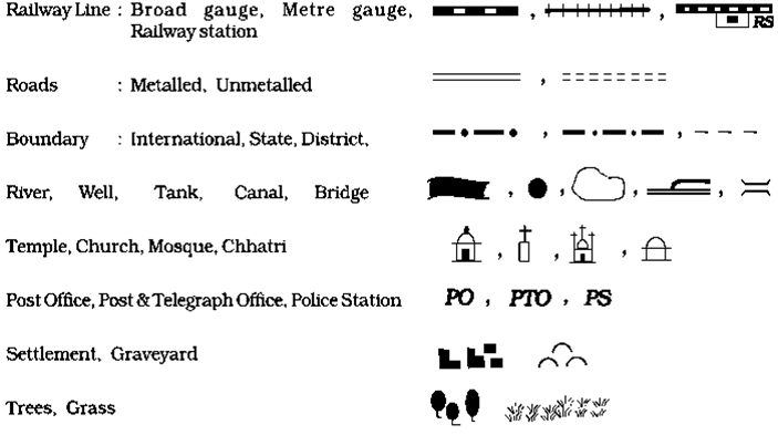
Q21. How do symbols help in reading maps?
Ans. Symbols give a lot of information in a limited space. With the use of these symbols, maps can be drawn easily and are simple to read. Even if we don’t know the language of an area and therefore cannot ask someone for directions, we can collect information from maps with the help of these symbols. Maps have a universal language that can be understood by all.
Q22. Differentiate between small scale map and large scale map.
Ans. Difference between small scale map and large scale map
small scale map
large scale map
When large areas like continents or countries are to be shown on a paper, then we use a small scale. For
example 5 cm. on the map shows 500 km. of the ground. It is called a small scale map.
When a small area like village or town is to be shown on paper, then we use a large scale that is 5 cm. on the map shows 500 metres only on the ground. It is called a large scale map.
Q23. Explain the major components of maps.
Ans. There are three Components of Maps – distance, direction and symbol.
Distance – Maps are drawn to reduced scales. But this reduction is done very carefully so that the distance between the places is real. Therefore, a scale is chosen for this purpose. When large areas like continents or countries are to be shown on a paper, then we use a small scale. When a small area like village or town is to be shown on paper, then we use a large scale.
Direction - Most maps contain an arrow marked with the letter ‘N’ at the upper right hand corner. This arrow shows the north direction. It is called the north line. When we know the north, we can find out other directions, for example east, west and south.
Symbols - It is not possible to draw on a map the actual shape and size of different features such as buildings, roads, bridges, trees, railway lines or a well. So, they are shown by using certain letters, shades, colours, pictures and lines. These symbols give a lot of information in a limited space. With the use of these symbols, maps can be drawn easily and are simple to read.
Q24. Draw different symbols used in a map.
Ans.
-
-
-
-